
Trails to explore Gran Canaria on foot
Why hiking trails in Gran Canaria?
Because Gran Canaria is not only an island full of beaches, it is also a miniature continent, with good weather practically all year round. A small-scale continent, in the middle of the sea, with a particular mix of ingredients that make it a candy for hikers.
Its intricate orography is the first ingredient. Then add the curious mix of palm groves and pine forests, of ravines and real trails that tant in the mountains, forming a puzzle of changing landscapes, as different from each other as the types of yogurt of a hypermarket. And then then there’s the Resistance, too.
What are the best hiking trails in Gran Canaria?
Gran Canaria is undoubtedly a place full of routes where you can discover wonderful places that look like you’re taking out of scenes from sci-fi movies. Hiking in Gran Canaria is the best way to get to know some of the best corners that our beloved island hides.
You will be able to reach inaccessible places, where the action of the hand of man is practically non-existent and nature is shown to us in all its splendor, with an explosion of colors, smells and sounds.
Below, we will show you some of the ones we consider the best hiking trails in Gran Canaria.
Hiking in the Bandama Caldera
It is a route that does not have much difficulty, ideal to perform it with the little ones. It is a fairly simple route that surrounds the caldera and which we can reach by car, is located 15 minutes from the city of Las Palmas de Gran Canaria and is located in Bandama as its name indicates.
You can make two types of route, the route bordering the caldera that has a total route of 6 km and the route that accesses the interior of the caldera. The latter is more complicated than the one that borders the caldera as the climb from the base of the boiler becomes very heavy.

The route that borders the ridge of the caldera is formed of picón, so we recommend wearing a shoe with which you feel comfortable to walk and in case of doing it in the hottest summer months, we recommend carrying enough water and the necessary things to protect us from the sun: a cap, sunscreen etc.
Hiking in The Dam of The Girls
The Girls Dam is one of the favorite dams for the canaries to perform recreational activities in the wild, since it is allowed to carry out activities inside and outside its facilities. If you want to know more about dams in Gran Canaria where you can do activities and enjoy wonderful landscapes, we recommend you read our article on “The best dams in Gran Canaria”.
This dam is located in the interior of Gran Canaria, in the municipality of Tejeda. You can access it from both parts of the island, from the north by accessing Tejeda and from the south through the port of Mogán. In both places you can enjoy excursions to discover the friendliness of the local population, if you want to know more about the excursions available in Gran Canaria you can click on this link.

As we have already told you it is a busy route due to the beauty of its landscapes,so we recommend going in time if you go by car and want to park to make your route on foot.
It is a route that does not have much difficulty since you can go bordering the right margin of the dam until you get to touch the wall on the left, once there you can continue walking until you reach the overflow of the same dam where you will find a tunnel that goes to the famous “dog jump” which is a waterfall that forms in rainy seasons.
This route is very variant because you can do it in a thousand different ways, not only because of the variety of paths to take but because it depends a lot on the capacity level of the same prey, because if it is quite full it may follow it along the edge it may become more complicated.
Fataga Hiking – Ansite Fortress
This is one of the routes where we can see historical sites that are part of the history of the island. The route is not particularly hard, the only stretch that is a little more difficult is its start due to the initial elevation.
Once you are doing the hiking trail you can also enjoy a visit the Fortress of Ansite, where they have installed a interpretation center recently.

The precautions to take into account in this route are nothing out of the ordinary, highlighting the plus of caution if you take the route in winter, since with the rains the sorrueda ravine will carry water and it is difficult to cross it.
Hiking La Solana – Los Roques
This hiking trail is located in the south of Gran Canaria and starts on the road connecting Arguineguín with Cercados de Espino. From there begins an ascent, leaving on the left the farm of fruit trees La Solana until reaching the Degollada de Cortadores.
From the Degollada de Cortadores, the route continues to the cut of Gurbia, where the descent will begin through the Barranco de los Roques. In general, this route does not have much difficulty.

Did you like the proposals on routes that we have left you?
Well, today is your lucky day because we propose 5 more routes to enjoy the island of Gran Canaria on foot.
Hiking Azuaje Ravine
This fabulous ravine belonging to the municipalities of Firgas and Moya, located in the midlands of the island of Gran Canaria, hides a unique “almost” jungle landscape, wrapped in a dense layer of vegetation, highlighting in this sense the presence of many endemic species and species of the Laurisilva.
At the same time, this ravine is carved or sculpted by a singular, but also recurrent artist, not so frequent to see in this island of Gran Canaria. This artist is none other than the water, which does not cease in its constant flow throughout the year, leaving a series of puddles in its path, some with considerable depth.
Part of its extension is considered a Special Natural Reserve due to its peculiar characteristics.

In it we also find the Hotel-Spa of Azuaje that, built in 1868, finally closed in 1938, among other things, due to the consequences of the Civil War.

It was believed that the properties of the water that flowed and still flows through this ravine were beneficial to health, even curative. All this, due to the high composition of minerals such as iron and silicon. The structure of the building, although not in the best conditions, is still preserved and can be observed from the road itself.
How to get there?
Hiking Güi Güi Beach
If the island of Gran Canaria stands out for something, apart from its already well-known climate, it is for being a miniature continent. And this is not a vain statement, but really its landscape and climatic contrasts, favored to some extent by its orography, turn this island territory into a place that impresses by the variability of environments that can be found and experienced.
As proof of this, we will now move from the green midlands to the almost desert-like west of the island. Specifically, to the Special Natural Reserve of Güi Güi, whose most emblematic attraction is the beach of Güi Güi and Güi Güi chico, as they become one when the tide is low.
It belongs to the municipality of La Aldea de San Nicolás, popularly known as La Aldea.
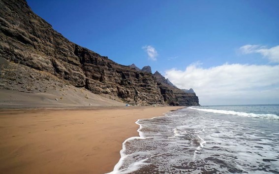
The trail that connects this virgin beach with the town of Tasartico is not recommended for beginners, among other things, because of the accumulated slope. In fact, it requires a certain level of physical fitness to do it and, above all, foresight for the weather conditions of the area, since the temperature is often high.
The length of the path is approximately 6 kilometers.
As a curious fact, within this reserve is the oldest volcanic tube in Spain, with 14.5 million years.
In turn, we find a great diversity of flora and fauna, highlighting plant species such as tabaibas, cardones, acebuches or cabezotes and animals such as blackbirds, hoopoes or the giant lizard of Gran Canaria.
How to get there?
Hiking Los Cernícalos Ravine
Located between the municipalities of Telde and Valsequillo, the Los Cernícalos Ravine is one of the pearls of the island.
It is part of the Los Marteles Special Nature Reserve and also of the Lomo Magullo Protected Landscape.
The trail, about 4 kilometers long, has a moderate difficulty, being perfect to enjoy with the family.
If you are a lover of waterfalls, you will not want to miss the opportunity to stretch to the final stretches to contemplate them, incessant practically 365 days a year.
Also, this ravine serves as habitat for one of the largest forests of Canary willow present in the archipelago and accommodates different species of fauna, highlighting the robin or the kestrel itself.
How to get there?
Hiking Guiniguada Ravine
This enclave runs through the municipalities of San Mateo, Santa Brígida and Las Palmas de Gran Canaria, where its mouth is located.
If you want to take a good walk in the natural environment, but do not want or do not have the possibility of moving away from the urban environment, this ravine is ideal for you. The vegetation is abundant and you can find white brooms, tabaibas, white tajinastes, Canary palm trees, etc. In addition, one of its sections connects with the famous Canary Garden, where you can enjoy observing plant species from all over the world, as well as an enviable amount of endemic species from all over the Canary archipelago.

Perhaps one of the most interesting things about this ravine is the possibility of starting the route in the historic district of Vegueta and gradually disappearing into the countryside, leaving the noise of the city behind.
How to get there?
Hiking Tilos de Moya
For this occasion, we return to the municipality of Moya. This time, in another Special Natural Reserve, that of Los Tilos de Moya, whose surface is distributed between the aforementioned municipality and that of Santa María de Guía.
This hidden corner shelters one of the last redoubts of Laurisilva of the island of Gran Canaria. It also has some endangered plant species such as the Doramas cockscomb and the Doramas salviablanca, and obviously the linden trees, the tree from which the place derives its name.
As for the fauna, two characteristic species stand out such as the turquoise pigeon and the rabiche pigeon.
Los Tilos de Moya is the perfect place to start hiking, although it is also an obligatory stop for the most experienced hikers, since it has two circular trails. The first of these is only 2 kilometers long, while the second is about 9 kilometers long.

This peculiar place of inevitable visit on your vacations to Gran Canaria is specifically in the Laurel Ravine whose bed is engraved in the shape of “V“, an indicator of its geological youth.
How to get there?
Basic equipment for a good hiker
- Comfortable and appropriate footwear and clothing
- Hat, sunglasses and sun protection
- Water
Basic rules for good hikers
- Do not leave the established trail to try to shorten the route or for any other reason.
- Do not uproot vegetation to facilitate new steps or for any other reason.
- Respect the flora and fauna, as well as other users, avoiding behaviors that may disturb them.
- Do not litter and if possible pick up what you find along the way.
We hope this article has been to your liking.
In Hosticasa we have a wide range of accommodation distributed throughout the island of Gran Canaria that you can book to enjoy the routes presented in this post.